The Trouble with Mr. Mini

By Peter Sedwick

In my last post, I provided some background on my group’s goal of measuring the levels of iron in the Ross Sea during late fall and early winter, when deep mixing brings this essential “micronutrient” up from the seafloor and into surface waters, where phytoplankton will make use of it during the coming spring bloom (which starts around October in the Ross Sea).


Team members Bettina Sohst (kneeling) and Casey O’Hara (right) load water samplers on to the trace metal CTD rosette for an early morning cast (photo: Bettina Sohst).

Team members Bettina Sohst (kneeling) and Casey O’Hara (right) load water samplers on to the trace metal CTD rosette for an early morning cast (photo: Bettina Sohst).

In the Ross Sea, dissolved iron is present at concentrations that range from around one- to one-hundred parts per trillion.   At these very low concentrations, it is a challenge to collect and process seawater samples on our metal ship without contaminating them with iron – that is, without accidentally adding iron to the samples, which would completely invalidate our results. Aboard the ship, particles containing iron are present in the air, on our clothes, and just about everywhere!


To avoid contaminating our seawater samples, we have to use specialized “trace metal clean” methods, which were first developed by Clair Patterson at the California Institute of Technology, for measuring trace levels of lead in the environment. To collect our seawater samples, we use specialized non-metal samplers that are mounted on a trace-metal CTD rosette.

An afternoon deployment of “Mr. Mini” from RVIB Nathaniel B. Palmer (photo: Bettina Sohst).

An afternoon deployment of “Mr. Mini” from RVIB Nathaniel B. Palmer (photo: Bettina Sohst).


This sampling device is smaller than the ship’s regular CTD rosette — hence it’s nickname of “Mr. Mini” — and it has no exposed parts that contain iron: external metal parts are either titanium or coated in plastic. Mr. Mini’s sensors record its depth, as well as water temperature and salinity (salt content), as it is lowered from the ship to collect seawater samples at pre-programmed depths below the surface, with the depth-temperature-salinity data being downloaded once the package is safely back aboard.


But Mr. Mini’s diminutive size has led to some unexpected wrinkles in our sampling routine. Our CTD rosette package is so light (around 200 pounds) that the trace metal winch, which lowers it over the side of the ship on a plastic coated line, hasn’t been able to accurately keep track of the amount of line out. As a result, our first sampling cast, done at the edge of the continental shelf, ended up with over 2,000 meters of line out, in a total water depth of around 1,550 m! Luckily, owing to a strong current, Mr. Mini avoided a potentially damaging encounter with the seabed, even though the downloaded data revealed that it had reached a total depth of 1570 m. Phew!

Marine technician Carmen Greto, who isn’t afraid of heights, hangs the new metering block during a brief stop in the ice pack (photo: Pete Sedwick).

Marine technician Carmen Greto, who isn’t afraid of heights, hangs the new metering block during a brief stop in the ice pack (photo: Pete Sedwick).


Our very able marine technicians have solved this problem by passing the winch cable through a “metering block”, which will record the exact amount of cable that is let out during the cast. Today, however, all sampling is on hold, as we enter Terra Nova Bay during a “katabatic wind event”, with icy winds pouring down off the Antarctic continent. With wind speeds gusting over 70 miles per hour and a wind chill of -55° Celsius, nothing is going in the water just yet…


Katabatic wind event in Terra Nova Bay - no trace metal cast today! (photo: Pete Sedwick).

Katabatic wind event in Terra Nova Bay – no trace metal cast today! (photo: Pete Sedwick).

Katabatic Wind Event!

Well, it happened. We finally made it to Terra Nova Bay, and as we entered we ran smack into a katabatic wind event. To recap, these are strong winds that blow off the Antarctic continent, typically lasting for 12 – 48 hours**. In the process the winds push all the sea ice away from the coast exposing the entire ocean to the full force of atmospheric heat loss.

Automated Weather Station from Inexpressible Island, Antarctica

Automated Weather Station from Inexpressible Island, Antarctica

Weather Conditions on the NBP. Note the -50 C wind chill and the 61 knot wind speeds

Weather Conditions on the NBP. Note the -50 C wind chill and the 61 knot wind speeds

Kelly Shick, our on-board weather forecaster, has been downloading Automated Weather Station data from Inexpressible Island (great name – I can imagine how this place can inspire inexpressible feelings of,… melancholy, desperation, and beauty?), which is in the middle of the Terra Nova Bay wind stream. As forecast, the wind began to increase at 12Z on April 30 (see image) and has been holding steady at 60 knots!

We are presently at 75 °S and 165.5 E. Overnight we drove right to the next station, and bam! – we were in open water again. Despite being up against the Nansen glacier 100’s of kms into the sea ice pack, there was a wind swell 8-10 ft estimated by the bridge. We tried to drive into the wind, and the windscreen in the bridge froze up with sea spray. Any water that hits the boat freezes solid. Now, we’re running downwind, waiting for things to calm down, so we can observe the event on the ocean. We are experiencing sustained winds of 60 knots (70 m/hr, or 30 m/s) with gusts to 70 knots. Wind chill is -51 °C, and the ocean surface is like oatmeal. It wants to freeze solid, but the wind and waves won’t let it.

Most of science activities are on hold until the winds calm, but Peter Guest is launching radio sondes from the helo deck, so at least we can measure the atmospheric boundary layer.

The lore aboard the NBP is that this is only the second time a boat has been in here this time of year. I can see why. There would be no good reason to come here or stay here, unless you came specifically to observe these conditions.

**From Kelly Shick: Katabatic winds occur when cool air pools up high in the Antarctic mountains. When the air cools, it becomes more dense. When enough of this air pools up there arises a situation when the system is unstable – cooler, heavier air higher up than (relatively) warmer, lighter air. The cool air then rushes off the higher elevations on the continent across the ice creating what is called a katabatic jet. These high winds (in excess of 50 knots) work to move away the already formed sea ice near the continent and jump start the formation of new sea ice. While the mechanism that kicks off the katabatic wind event is still not well understood (something the PiPERS meteorology team hopes to work on during this cruise), the wind events seem to occur on a semi-regular basis and last for 24-36 hours. The PiPERS cruise is arriving in Terra Nova Bay right on time capture some of most interesting and vital data. Here’s to high winds ahead!

Ice Stations: Physics in the endless white

By Maddie Smith
The United States Antarctic Program (USAP) has for many years provided scientists and support workers with a critical piece of gear to survive frigid work on the ice – bunny boots. When I first heard of bunny boots, the name conjured images of a cozy, fluffy, furry boot. On the contrary, bunny boots are a stiff rubber, with the main similarities to bunnies in the full round shape and snowy white color. The wonder of bunny boots is in the insulation provided by the layer of air between the layers of rubber, which creates a surprisingly good barrier from the ice underfoot. I was outfitted with Bunny Boots at the USAP clothing warehouse in Christchurch (along with “Big Red”, a parka and another USAP classic). The first ice station was my first time wearing them, and I am pleased to report that my perpetually cold feet stayed comfortable even at -20˚C. There was a feeling with them on of being an explorer, like an astronaut, stepping out onto the un-trodden.
Bunny Boots in action: Sharon Stammerjohn (left; UC-Boulder) and Sarah Searson (righ; NIWA) recovering the SeaBird CTD. They used this to measure profiles of temperature and salinity in the ocean down to 100 m beneath the ice station.

Bunny Boots in action: Sharon Stammerjohn (left; UC-Boulder) and Sarah Searson (righ; NIWA) recovering the SeaBird CTD. They used this to measure profiles of temperature and salinity in the ocean down to 100 m beneath the ice station.

We are thankful for the extreme gear that gets us through the extreme and demanding conditions of ice stations. At an ice station, we are collectively on the ice from first light to often well after dark. Before first light, the Chief Sci and PI’s (Chief scientist and principal investigators) are up on the bridge of the ship, searching the horizon for a piece of ice that is interesting enough, thick enough, and large enough to support all-day operations. As soon as we’re secured against the ice to the captain’s satisfaction the MT’s (Marine Techs) install the gangway and begin offloading snowmobiles and science cargo. As soon as a safe perimeter has been set, science operations begin.

Gangway to the ice. On the ice is Ben, our field safety officer, who is a mountain guide in the real world and in charge of on-ice safety on the ship.

Gangway to the ice. On the ice is Ben, our field safety officer, who is a mountain guide in the real world and in charge of on-ice safety on the ship.

The beginning of our first ice station, with the Biogeochemistry team setting up their station in the distance. They spend 8-12 hours sampling to thoroughly characterize the atmosphere, sea ice, and ocean below.

The beginning of our first ice station, with the Biogeochemistry team setting up their station in the distance. They spend 8-12 hours sampling to thoroughly characterize the atmosphere, sea ice, and ocean below.

At most ice stations we will have both a “Physics Station” and a “Biogeochemistry Station”; I’ve been helping with the Physics stations. When the team picks a sufficiently interesting ice floe in the morning, they are looking for something with topography and history. Throughout the day, we will analyze the floe from top to bottom. The surface topography of the floe is mapped using a Lidar scanner. We carefully measure snow thickness, freeboard (depth to the water), and ice thickness at 1-m intervals along a 100-m line to match up and get a snapshot of the topography on the bottom of the ice floe. Sometimes, an autonomous underwater vehicle (AUV) is flown under the ice to completely map the bottom topography. This will be matched up with the surface topography to give us a complete 3D picture of the floe. Cores are taken from the ice. These cores will be later analyzed to understand the history of the ice, where layers of ice are like tree rings that tell the conditions throughout its formation.

We are also trying to capture the conditions contributing to ice formation – the atmosphere above the ice and the ocean below. Unmanned aerial vehicles (UAV) are flown to both capture mosaic images of the floe and to measure interesting features in the wind in the atmosphere above the ice. An atmospheric met station is set up to measure the movement of heat (fluxes) towards or away from the ice. Profiles of ocean temperature and salinity beneath the ice are measured at multiple points throughout the day. This helps us understand how the water masses below are evolving as a result of ice formation. And all this is only the Physics station – at the Biogeochemistry station, they measure a whole other suite of variables. In the years of data analysis to come, each piece will work together to help us figure out the puzzle of ice formation.

Peter Guest (Naval Postgraduate School) installing the meteorological tower that measures atmospheric heat fluxes over the ice. (photo: Lettie Roach)

Peter Guest (Naval Postgraduate School) installing the meteorological tower that measures atmospheric heat fluxes over the ice. (photo: Lettie Roach)

Doing work on the ice feels drastically different from doing work on the ship. In some ways, it reminds me of the department-wide geology field camps I did as an undergrad, or of summer camps. Much of the group is out on the ice at the same time, everyone spread out and hard at work at their respective sites. It’s incredibly peaceful, with the rattle of the ship’s engines almost completely gone. Occasionally, the call of a nearby Emperor Penguin punctuates the air, and I imagined he’s raising his concern at the hoard of creatures in orange suits setting up camp on the ice. How strange we must look to him!

As we move further south and into winter, we are rapidly losing daylight, and soon will be doing work mostly in the dark. The dwindling daylight at the very least makes for beautiful extended sunsets and sunrises. The ice is a beautiful, seemingly endless white landscape, with the mountains of the continent forming a stunning backdrop. Days on the ice are exhausting, but I can’t complain.

Sun sets over the Palmer

Sun sets over the Palmer

Iron and the Importance of the Wintry Mix

By Peter Sedwick


I’m writing this from latitude 63 degrees south, where the research icebreaker Nathaniel B. Palmer is wallowing through a building swell that’s been whipped up by a night of 30 knot winds. Outside it’s gray and wet and miserable – a pretty typical day in the Southern Ocean.   We’ve been at sea for nearly a week, completing some oceanographic sampling on our way south from New Zealand, and in another couple of days we’ll be in the Antarctic sea ice, which is the main focus of this research voyage.


As part of the PIPERS cruise, my research team from Old Dominion University (Bettina Sohst, Casey O’Hara and myself) have been awarded funding from the U.S. National Science Foundation to collect seawater samples for post-cruise measurements of iron, in an effort to understand how iron levels in the Ross Sea are impacted by the vertical mixing and sea ice formation that begins in austral fall and continues over the winter months (roughly April-September in the Southern Hemisphere).


Why the interest in iron? During the austral summer ‘growing season’, the supply of this essential micronutrient is thought to set a limit on the growth of phytoplankton over much of the otherwise nutrient-rich ocean that surrounds the Antarctic continent. Phytoplankton are tiny, single-celled plants that grow in the sunlit surface ocean, and are important because they provide the foundation of the ocean’s ecosystem; they produce around half of the oxygen in our atmosphere; and they play a key role in moderating Earth’s climate, by regulating atmospheric carbon dioxide.


For these reasons, we are trying to better understanding the supply of iron to ocean waters around Antarctica, and how this might change as Earth’s climate warms. For the PIPERS expedition, our main study region is the Ross Sea, a large embayment that covers more than 400,000 square kilometers of the Antarctic continental shelf, with an average water depth of around 500 meters.


Here phytoplankton growth is limited by low levels of iron during the summer months (November-March), although not as severely as in the deep offshore waters of the Southern Ocean. We think this is because surface waters of the Ross Sea receive iron from two major sources before and during the growing season: iron-rich bottom waters that are brought to the surface by deep winter mixing, and the melting of sea ice in spring and summer.


However, we don’t have a good understanding of these sources because we have no observations of iron in the Ross Sea during the fall and winter, when the deep mixing occurs and sea ice forms. The PIPERS cruise provides a unique opportunity to make these observations, alongside the important observations of vertical mixing, sea ice formation, vertical mixing and sea ice composition that will be made by other groups that are involved in the expedition.


Stand by for more information about our ‘clean’ sampling methods and more pictures of team iron once we get into the ice …


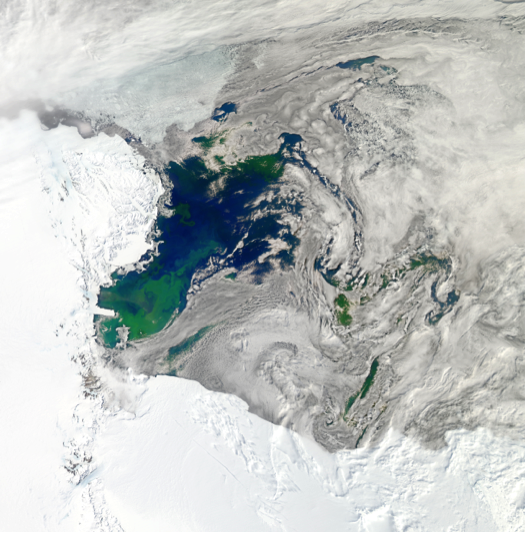
Satellite image of our study region in the Ross Sea during summer, with large phytoplankton blooms clearly visible in green (image: NASA).

Satellite image of our study region in the Ross Sea during summer, with large phytoplankton blooms clearly visible in green (image: NASA).


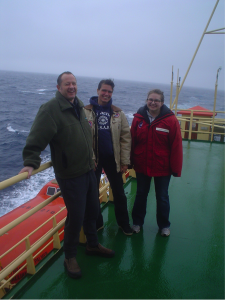
Old Dominion University’s ‘Team Iron’ (Pete Sedwick, Bettina Sohst and Casey O’Hara) enjoying the Southern Ocean weather aboard RVIB Nathaniel B. Palmer.

Old Dominion University’s ‘Team Iron’ (Pete Sedwick, Bettina Sohst and Casey O’Hara) enjoying the Southern Ocean weather aboard RVIB Nathaniel B. Palmer.


A Tale of the « Dragon Skin » sea ice

[By Jean-Louis Tison, Universite Libre du Bruxelles]

Dragon Skin

Dragon Skin next to the NBP as we icebreak our way south to Terra Nova Bay.

Hi everyone!…This is Jean-Louis Tison, one of the Belgians on board!..I thought I’d drop you a few words about our new exciting sight of yesterday, 28th of April. If you are a faithful PIPERS follower, you might have already seen pictures like the one shown here to the left, a breathtaking view of this peculiar type of sea ice, extending for miles around the ship. It does not require a lot of imagination (neither to be a fan of “Games of Throne”) to describe it, as a few of our predecessors already did, as “Dragon skin sea ice”…Indeed “a few”, since this is quite a rare sight, only seen twice by our Chief Scientist Steve (in his long career!) and once, more recently by Guy (Williams) during the Antarctic SIPEX I expedition. Vladimir, our “ice pilot”, as also seen it a few times in the Arctic. For me, it was a first! As you can see (overturned) on the side of the ship, it indeed consists of a thin layer of individual pancakes “stranded” on 60-80 cm of consolidated sea ice. As you know well, scientists are curious animals, and lively discussions quickly started to understand the origin of this “Dragon skin”. Not only scientists, by the way, and we were quickly pressed by our ASC friends and the crew to propose decent clues of interpretation!..
It quickly came to our mind that this peculiar type of sea ice might be the “signature” of the polynya activity, that we are here to better understand, and more specifically of the strong wind regimes that characterize it!…Let me try to explain you “how”, with the help of a little hand drawing here below (apologies, these are very busy times, and not much space is available to produce a digital equivalent!…I hope you will be able to read it through as I describe it!.. Don’t hesitate to blow it up to see the comments better!).

Diagram showing the formation of dragon skin, as pancake ice becomes rafted on top of thicker columnar ice, downstream of a polynya

Diagram showing the formation of dragon skin, as pancake ice becomes rafted on top of thicker columnar ice, downstream of a polynya.

As you probably know now, polynyas (a Russian word) are permanent open water areas within the sea ice cover, generally located in coastal areas. They persist because of the frequent very strong and cold winds that flow down the slope of the ice sheets that we call “katabatic winds”. Our first polynya of interest will be the “Terra Nova Bay polynya”. Because of those strong katabatic winds, individual ice crystals (frazil ice) form in extremely large quantities at all times, and are quickly blown away to the open ocean, at least over a distance of a few tens of kilometers, where the katabatic winds lose their strength. During periods of quieter winds, however, frazil ice crystals will conglomerate and form thin pancakes. These will quickly be partly broken up by the next strong wind event (sometimes above 120 km an hour) and strongly pushed against and on top of the ice at the rim of the polynya, resulting in the so-called “dragon skin” sea ice.

Oceanographically, ice formation in the polynyas is an extremely important process!.. Since ice rejects a fair amount of salts (nearly 90 %) in the water below, the latter becomes more saline and denser, and will sink to become Antarctic Bottom Waters, a major component of the Global oceanic conveyor belt. Also, the ice formed in the polynya is entrained by wind and currents to form a vast “plume” of “fresh water” (compared to sea water), in our case to the North-East of the Terra Nova Bay polynya.
There is still some debate amongst us, as to the nature of the ice located at the rim of the polynya. It could be a) pre-existing sea ice drifting from the South of the Ross Sea (lower box A in my drawing); b) sustained loose frazil accumulation during continuous high-wind periods at the rim of the polynya (lower box B in my drawing) or c) piles of thin pancakes formed during previous cycles of high/llow winds, accumulated at the rim of the polynya, blocking the way to the “newcomers”” that override it. This is not a vain debate amongst enthusiast scientists, since it will partly control the efficiency of the polynya in exporting fresh-water ice to the open ocean. Option A seems somewhat unrealistic, , though, since it is difficult to explain the formation of the bands of dragon skin sea ice we have seen spreading over several tens of kilometers. Our first ice coring today under the dragon skin seems to favour option B…and we are therefore quite impatient, as you can imagine, to see what we will encounter as we penetrate further South, entering the immediate vicinity of the polynya…still two nights to wait :0)!..
I hope this has helped you to understand our excitement, In a way or another!…Stay focused on our new adventures in the coming days!..
Greetings from 74° South, Jean-Louis.

PIPERS faceboard


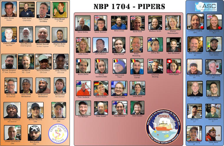
The PIPERS (NBP17-04) faceboard.

The PIPERS (NBP17-04) faceboard.

Meet the faces of NBP17-04:  The crew of RVIB Nathaniel B. Palmer, the amazing technical staff from the Antarctic Science Contract (ASC) and of course the science team.  Also updated to the Science Team page (http://geotracerkitchen.org/pipers/?page_id=43).

Steel-toes, bunk beds and “What day is it anyway?”

(by Bettina – technician and lab manager in the OEAS department at ODU)


Life onboard a research vessel changes everyone’s tried and true daily routine completely. There are no 9-5 work-weeks or weekends. Safety comes first for everything. And recreation often happens only in the form of a few hours of sleep.


When a person, who is not connected to our line of work, hears that I work in the field of oceanographic research, the first picture conjured in their mind is usually of Cousteau, bikinis and dolphins. Reality could not be farther from this popular dream picture.


Only few oceanographic research expeditions (We call them “cruises” only among ourselves, as this invokes the vision of a Carnival trip) sail to warm waters, and almost all are focused on work, work, work. Ship time is precious, so it dictates our daily routine. 24 hour operations are the norm.


Most workdays are at the very least 12 hours long (if you are “lucky” and share a 24 hour workday with another person in watches). Often this stretches much beyond, even to work periods longer than 24 hours at times.


Safety is the one most important goal on any expedition. A ship, especially in remote areas (and it can’t get more remote than Antarctica), bears many hazards, and everyone on board needs to show constant vigilance to prevent injuries, damage, failure, etc. Working on a constantly moving platform alone can make normal tasks rather tricky.


Deployed equipment in rough seas.

Deployed equipment in rough seas.

The crew on research vessels is thoroughly trained in keeping us safe as well as in educating us. Usually the beginning of a trip is littered with safety briefings. On this trip we already sat through “General safety and hazard awareness”, “Ice safety”, “Zodiak rules and ladder training” etc., and of course the always present, weekly fire-drill! The first one happens right after departure, with a repeat every week.
This does have its advantages: When all we do is work, weekdays blend into each other, so a fire-drill tells us, which weekday it is. In our case here on the Nathaniel B. Palmer, Wednesday is fire-drill day. When the alarm bell rings around mid-day, grab your floatation device, survival suit, grab-bag with hat, sunscreen, water, important documents etc., and proceed to the muster station.


Emergency suit testing during a fire drill.

Emergency suit testing during a fire drill.


As time moves along, the faces seen at these gatherings tend to look increasingly tired. Some people even get ripped out of their bunks in the middle of their sleep.


Speaking of bunks: Accommodations are also much different than our cozy places at home, although the NBP is quite luxurious, compared to other research vessels. Staterooms are equipped with only the necessary, beds are bunk-style with two people to a room, and rather narrow. However, nothing beats the gentle rocking of a ship to lull you into sleep!
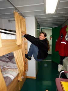
 

Bunk beds and their versatility.

Bunk beds and their versatility.


This same rocking also turns showers into a whitewater experience. That bar inside the shower can come in quite handy, and toweling off can resemble yoga.


Another aspect to get used to is the background noise level. A steel ship carries any sound, including the engines, happily chirping echo sounder and human conversations. While some white noises, like the hum of diesel engines, can be soothing, others require acceptance or adjustment. One of the first things I usually do is de-squeaking and de-rattling my stateroom. Duct tape, cardboard and plastic wedges come in really handy here.


Privacy is hard to come by. If you imagine 300 feet of ship with nearly 70 people on it, you can understand how difficult it can be to find some me-time. People get inventive, though, and can be hiding in strange places. If you find them there, you won’t get more than a grunt. Privacy is sacred.


Food is provided on board. In fact, the cooks are usually some of the hardest working people on the ship. Feeding a herd of hungry sailors is no small feat.
Here on NBP we have the opportunity to consume four meals a day: 7:30 breakfast, 11:30 lunch, 17:30 dinner and 23:30 midrats (midnight rations), each an hour long. We are provided with the nutrition needed to keep chugging in the cold, harsh environment of Antarctica. However, on a 65 day tour like this one, certain food items do run out eventually. The bananas are usually the first to go, followed by other fruits and fresh vegetables, and later on yogurt and co. That’s when food moods start to drop. Many people bring their own “culinary happy places” in form of chocolate, espresso or cheese for example.


Even our daily clothing differs quite a bit from what can be seen on land. The pretense of “looking good” goes overboard quickly, when you realize that jeans and sneakers get (and stay) wet and cold, frilly clothing items get stuck in cables, nooks and crannies, and your good clothes will eventually all fall victim to the curse of the seafaring washing machine (rust spots, bleached colors and saggy fabric) and also collect grease spots and tears. But nobody really minds. If it is warm and comfortable AND protects you (hence the steel toed boots!), you wear it.
One popular entertainment on board are the newly introduced t-shirts at the beginning of a trip. Reading everyone’s shirts becomes a favorite pastime.


Finding entertainment can become rather inventive here. We are lucky and have a self-proclaimed “morale-team”. On Easter Sunday we all got to play bingo with the Easter bunny. A welcome distraction made possible by the fact that we are not in full station work mode, yet.


Additionally, the NBP offers a small gym, a sauna, a movie lounge with a good selection of movies, a library, and even (very limited, but workable) internet!
If we do get that precious moment to recreate, we enjoy it as much as we can.


While all this sea life may sound nearly unbearable to some of you, it is worth it, if you love the seagoing jobs! Nothing beats the ever-changing view of an endless ocean, your face in the wind, the occasional sights of amazing places and wildlife, the knowledge gained from new data and instrumentation, or the development of new friendships and of a somewhat dysfunctional family bond onboard, and, of course: Ocean sunsets!!!


Royal albatross

Royal albatross

We may see more dark than sun on our fall/winter season trip in the southern hemisphere, but we are hoping for the aurora australis!


And ice has its own, ever-changing beauty and fascination.


Ask a sailor how life onboard truly is. You will hear some unusual stories. :)

Life on Board

Post by Jeffrey Mei


Kia ora from the only Kiwi aboard this ship!


As I write this, we are at 58 degrees south, well past the NZ Exclusive Economic Zone and almost at our first float deployment (at 60 south). On our way, we briefly went through what (some of us decided to call) the southern Bermuda Triangle, pictured below.


The ship passing through the ‘Bermuda Triangle’. In reality, it is just where the EEZs of the various territories of NZ (in this case, the Chatham Islands, the South Island and Campbell Island) do not fully intersect.

The ship passing through the ‘Bermuda Triangle’. In reality, it is just where the EEZs of the various territories of NZ (in this case, the Chatham Islands, the South Island and Campbell Island) do not fully intersect.

As you can see, we were clearly trying very hard to entertain ourselves during the slow week-long jaunt down to our first float deployment.


Life on board is pretty sweet. Setting up the ship as the remnants of Cyclone Debbie passed through was probably the least fun aspect of the trip, but it was a good bonding experience for everyone, I suppose.


Food is great too – we get 3 (soon to be 4) meals a day and the atmosphere is generally very convivial. Everyone is on first-name basis with everyone else and people are all happy to talk about their work. This is my first major cruise (besides a little week-long trip on a small fishing boat in a fjord in Greenland) so it’s great to live and breathe science for 8 weeks!
One thing I did not realise in advance was the snack situation – naturally, everyone wants their own snacks and so the ship provides relatively few snacks. Except for Pringles.


So many Pringles.

So many Pringles.


I brought a bunch of Bundaberg ginger beers, though I am already halfway through my (very meagre) supply of 4, so I am thinking of how best to stretch out my remaining two for the rest of the trip…


Reppin’ NZ in my snack selection.

Reppin’ NZ in my snack selection.


There’s also an on-board gym. Using a rowing machine while the waves are rolling in the deep beneath you makes for quite an odd rowing experience, though presumably it is a more realistic simulation of rowing… The gym also has a stair climber, though I bet that gets used the least given how much stair-climbing we all do on a daily basis.


In short, morale is high aboard the NBP and all the science personnel are itching to start with their research! On Sunday, we are having our first morale event, which is bingo, and everyone is looking forward to that.

Happy Easter from the NBP!

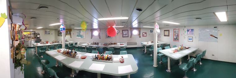
If you were worried that the Easter Bunny was not intrepid enough to visit us out here on the Southern Ocean, never fear because Easter and the bunny landed on the NBP in technicolor glory.  On Easter morning the crew and science staff woke up for breakfast to a galley fully decorated with eggs, balloons and streamers.

20170416_092832

When we got to our labs, we found little treats scattered all over the boat. Later in the day, a rather bearded Easter Bunny made the rounds with more treats, and at the end of the day, everyone played Bingo in the galley for more prizes!

Amy Belcher and Julian Race - the morale team, keeping us happy, aboard NBP17-04

Amy Belcher and Julian Race – the morale team, keeping us happy, aboard NBP17-04

All in all, it was a great way to break up the routine.  (Oh and we finally had our first CTD station, and deployed a SOCCOM float). Many thanks to the NBP17-04 morale Mom and Dad – Amy Belcher and Julian Race (pictured above).