Bouncing and shimying down to 66°S

Well, the roaring forties did not disappoint. We’ve had steady 40 knot winds for the past 24 hours, and it’s got us in a Southern Ocean state of mind.  The last few items not lashed or stashed made themselves known as soon as we started to roll.

For the NBP this is nothing. The boat rides extremely well, especially for an ice breaker, which tend to be shaped like bathtubs, so they can ride up on the ice and break through by their weight. For the rest of us, getting our sea legs takes a little longer. The labs have thinned out and people are napping their way through the queasiness.  In another day, most everyone will be acclimated, and these may be the. Only waves we see until the trip home, because the waves are damped out be the ice.

In the mean time, we make plans, have science talks in the evening, and a different safety drill after lunch each day.  Yesterday we tried on our immersion suits. Today will be lifeboat drills, and tomorrow begins on-ice safety!  The best is saved for last.

We’re presently passing through 48°S – another 47 hours until we exit the EEZ of New Zealand and we can turn our instruments on!

Pancakes for breakfast, lunch, and dinner

What’s flat, round, and white all over? If you guessed pancakes, you’d be right! But while the pancakes you’re likely thinking of are formed from a combination of flour, water, and oil, the pancakes I’m referring to are formed from the combination of the ocean, cold temperatures, and most importantly, waves. If the ocean is calm, ice forms as smooth sheets like you often see on frozen lakes in winter. If waves are present when the ocean is freezing, the motion of the waves results in sea ice that is flat and round with smooth edges, and so is termed pancake ice. Waves are often present in the Antarctic, and so much of the sea ice that forms begins as pancake ice.

pancakes-1

Pancake sea ice in the Arctic Ocean. See the resemblance?

While most people on the PIPERS voyage will be hoping for calm seas, I’ll be keeping my fingers crossed for waves! In the broadest sense, the PIPERS cruise is interested in observing the ice formation process. As most of the ice that forms in this region begins as pancake ice, waves are a crucial part of this story. But you might be wondering: why do waves mean that ice forms as pancakes? We generally understand that the collision of nearby pancakes as they crash together in waves (which you can see in photos both above and below) causes the upturned edges and round shapes that we associate with pancake sea ice. But the exact process isn’t known, which means that we aren’t able to predict when pancake sea ice will form and how big the pancakes will be.

Enter: stereo camera setup. The stereo cameras setup is comprised of two cameras that work much like the two eyes you are using to view read this screen to determine how far away objects are. These two cameras can then be used to measure waves on the ocean surface. (The middle camera is used to correct for the motion of the ship.) As you can see from the images below, we can also pick out pancake sea ice at different locations in the waves, and track it through subsequent images. This will allow us to record the collisions that we expect to be responsible for the formation of pancake sea ice.

pancakes-2

Stereo camera setup installed on the rail of the Sikuliaq in the Arctic Ocean. Stereo image pair depicts pancake wave motion during a large wave event.

These pancakes might not taste as good with a pat of butter and swirl of syrup, but understanding when and how pancake sea ice forms is a key part of understanding the future of the sea ice cover. Pancake formation can result in thicker ice pack; ice that forms as pancakes is thicker than sheet ice that forms at the same temperature. However, pancake formation can result in an ice pack that melts out faster come springtime; pack ice that forms from pancakes is less uniform that pack ice that begins as a sheet.

After pancake ice begins to grow, the fun has only just begun. We have many other questions about the relationship of ice and waves in the tumultuous waters of the Ross Sea: how rapidly do the waves from the Southern Ocean get attenuated by the ice in the Ross Sea? Does dissipation of wave energy enhance or suppress ice production in the strong winds of the polynyas? We’ll use a number of techniques to address these questions, including throwing in a bunch of wave buoys such as the SWIFT buoy in the image below.
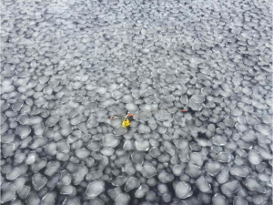
 

picture-3

SWIFT buoy in pancake sea ice in the Beaufort Sea. The SWIFT measures waves, as well as wind speed and direction, air temperature, water temperature and salinity, and mixing due to waves just below the surface.

It looks like we might get “lucky” in the upcoming crossing to Antarctica with waves predicted to be only 5-6 m (16 to 20 feet) most of the time. But don’t worry: this is more than enough to make some serious pancakes. In just a few days, we’ll be having pancakes for breakfast, lunch, and dinner.

Maddie Smith is a PhD student at the University of Washington. If you are interested in following along more with her journey on PIPERS, please visit her blog Maddie At Sea.

Stowing and lashing.

Final preparations are underway for our sail south to meet the ice. We will have nearly 8 days of transit, crossing the stormy Southern Ocean through the  roaring forties and furious fifties, until we reach the ice edge, predicted for 69 S (although it’s advancing quickly). Before we reach open seas, every object that can take flight must be put away (stowed), or tied down (lashed) so it doesn’t slide across the floor or become airborne if we take a wave.  

On the way south we will begin science with several CTD stations and the deployment of SOCCOM biogeochemistry floats. More on those soon. In the mean time ‘good on ya’ from New Zealand.

The Unpacking has Begun!

The halls, state rooms and labs of the RVIB Nathaniel B Palmer are buzzing with activity. The ship is now filled with scientists, antarctic support crew and ship crew all getting all the gear on board and ready for deployment. Yesterday (April 6) was a very rainy day as the crane crew was in full force moving (damp) boxes to the various labs. Scientists have been busy checking to make sure everything arrived (in one piece). Each of the science groups are claiming their territory in each of the labs and working to get all of their science gear set up and ready to go.


img_3022


Today the science team had a morning meeting to discuss where each of the teams are at with setup and to work through any issues teams are having. After lunch we were transported by bus to Christchurch (a half hour drive Lyttelton—where the Palmer is docked) to get our extreme cold weather gear. Everyone was outfitted with a number of clothing items–jackets, gloves, snow pants, face coverings, ice boots, ect.) We tried everything on to make sure it all fits and brought all of the gear back on the boat.


Everyone is very excited to get the science going and head off for the icy south. This year has been a complete change in the ice cover in the Ross Sea. For the past few years the Ross Sea has been seeing increased ice formation, however, this year’s ice cover has been low. Many of the scientists have been looking at the latest satellite images to help determine where the best locations are for the science goals of the PIPERS cruise. The latest images show a big increase in ice formation in the past week, which is promising for our ice sampling teams. We can’t wait to see it for ourselves!


I had a great conversation at breakfast with one of the principal investigators– Steve Ackley (University of Texas San Antonio). I asked him what his ideal outcomes from this cruise. He said, “It would be great for us to use each of the science teams’ data to help understand how this ice formation we see is affecting deep water formation. It’s not going to be a simple task. We can’t get a definitive answer from just one type of sampling. We need all of these different groups to come together to help get this full picture.” It really resonated with me to understand that this is very much a team effort. We are working together to really ground truth what models and satellites are saying about ice formation and ice concentrations in the Ross Sea. I am excited to continue meeting all of the scientists and getting the gear ready for sea!

-Sam Gartzman

University of Rhode Island

Polynyas are like stove pipes in the ocean.

rosssea_amo_2011320_lrg

The principle aim of the PIPERS project is to observe how sea ice and dense water are produced in coastal polynyas. The word “polynya” is Russian for “hole in the ice”.  It refers to a region of persistent open water that is surrounded by sea ice.  Coastal polynyas are kept open by strong offshore or “katabatic” winds.  These winds pick up sporadically, and blow as fast as 60 km/hr, typically for 18-48 hours.  These katabatic wind events push the ice out of the polynya, even as new ice is made from the extreme wind and cold air temperatures (well below -20 C in the winter).  This process of incessant sea ice production concentrates salt in the polynya producing the densest water in the global ocean.  Sinking dense water produces deep convection down to the ocean bottom, releasing ocean heat to the air and producing a deep column of seawater that exchanges gas, aerosols and other chemical species with the air.  This deep column will pick up some of the anthropgenic carbon dioxide (CO2) that we produce and convey that CO2 into the deep sea.  Deep convection over the ocean floor may also release methane, another greenhouse gas, from the sediments.

The water made in the coastal polynyas of Antarctica eventually sinks along the ocean floor to become part of Antarctic Bottom Water – the largest and densest water mass in the ocean. In this way, a polynya is like chimney or a stove pipe between the deep ocean and the atmosphere.

There is evidence that the rate of sinking and Bottom Water production is decreasing, but we will save that for another post.

Where is the NBP now?

Maybe the first question should be “What is the NBP?” The NBP is the Nathaniel B. Palmer, a 92 m icebreaker that is leased to the National Science Foundation every year as part of the US Antarctic Program science operations. Interestingly, the vessel was launched in ’92 (1992) and has been carrying out science operations since. Expeditions are numbered by the NBPYY-##, where YY refers to the last two digits of the calendar year, and ## is the sequential cruise number for that year. We are the 4th cruise already this year, hence we are NBP17-04.

R/V Nathaniel B. Palmer

So, where is the NBP? Have a look.